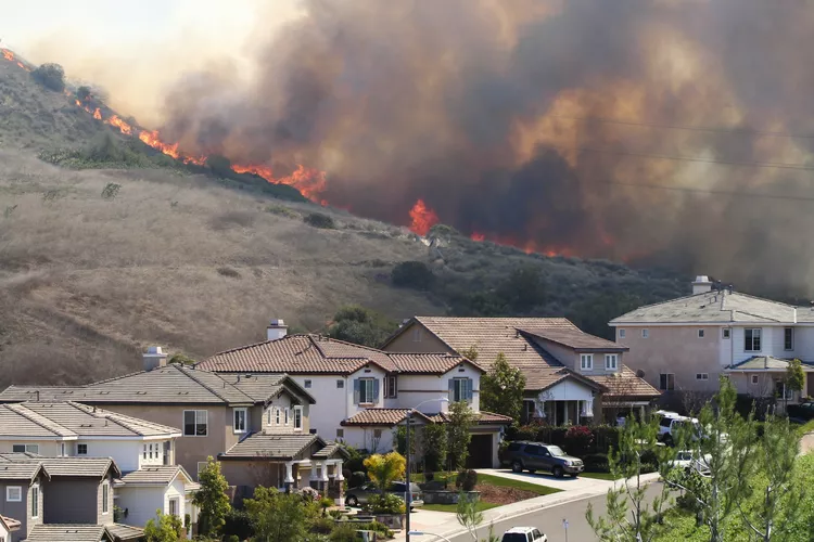
Wildfires are among the most destructive natural disasters, capable of consuming vast swaths of land, destroying homes, and endangering lives. But what many people don’t realize is that wildfires don’t ignite and spread randomly—they’re heavily influenced by specific atmospheric conditions known as fire weather. Understanding fire weather is critical for predicting, preventing, and managing wildfires. When I first delved into this topic, I was struck by how interconnected factors like temperature, humidity, and wind could create the perfect storm for disaster. If you’re curious about what fire weather is and how it’s monitored, let me break it down for you.
What Is Fire Weather?
Fire weather refers to the combination of meteorological conditions that increase the likelihood of a wildfire starting or spreading. These conditions include:
- Temperature: Higher temperatures dry out vegetation, turning it into fuel.
- Humidity: Low relative humidity further dries out plants and soil.
- Wind Speed and Direction: Strong winds can carry embers over long distances, igniting new fires (a phenomenon called spotting) and accelerating the spread of existing ones.
- Precipitation: Prolonged droughts or lack of rainfall leave landscapes parched and primed for ignition.
- Fuel Moisture: The amount of moisture in vegetation determines how easily it will burn.
When these elements align, they create an environment where wildfires can ignite quickly and spread uncontrollably. Fire weather doesn’t cause fires directly—it amplifies the risks posed by human activity, lightning strikes, or other ignition sources.
The Role of Fire Weather Indices
To quantify and predict fire weather, meteorologists use specialized tools and indices. These systems assess the potential for wildfires based on current and forecasted conditions. Some widely used indices include:
1. Fire Danger Rating Systems
- Many countries have their own rating systems, such as the National Fire Danger Rating System (NFDRS) in the United States.
- These systems categorize fire danger levels (e.g., low, moderate, high, very high, extreme) based on factors like fuel type, weather patterns, and terrain.
2. Keetch-Byram Drought Index (KBDI)
- Measures drought intensity by tracking cumulative moisture loss in the soil and vegetation.
- Higher KBDI values indicate drier conditions and greater fire risk.
3. Haines Index
- Evaluates atmospheric stability and humidity to determine the potential for large plume-dominated fires.
- Often used to predict explosive fire behavior in mountainous regions.
4. Canadian Forest Fire Weather Index (FWI)
- A globally recognized system that calculates fire intensity and spread potential using inputs like wind speed, temperature, and precipitation.
These indices help fire managers allocate resources, issue warnings, and implement restrictions during periods of heightened risk.
How Fire Weather Is Monitored
Monitoring fire weather involves a combination of ground-based observations, remote sensing, and predictive modeling. Here’s how experts track and analyze the conditions:
1. Weather Stations
- Networks of automated weather stations collect real-time data on temperature, humidity, wind speed, and rainfall.
- This information feeds into fire prediction models and helps identify areas at risk.
2. Satellite Imagery
- Satellites equipped with infrared sensors detect hotspots, monitor smoke plumes, and assess vegetation health.
- Tools like NASA’s MODIS and VIIRS satellites provide invaluable insights into active fires and fire-prone regions.
3. Drones and Aircraft
- Unmanned aerial vehicles (UAVs) and planes equipped with advanced sensors gather detailed data on fire behavior and environmental conditions.
- They also assist in mapping burned areas and assessing damage.
4. Forecast Models
- Numerical weather prediction models simulate future fire weather scenarios, helping authorities prepare for outbreaks.
- Examples include the North American Mesoscale Model (NAM) and the Global Forecast System (GFS).
5. Public Alerts and Warnings
- Agencies like the National Weather Service (NWS) in the U.S. issue Red Flag Warnings when critical fire weather conditions are expected.
- These alerts encourage communities to take precautions, such as avoiding outdoor burning or campfires.
Why Fire Weather Matters
The importance of understanding fire weather cannot be overstated. It plays a key role in:
1. Prevention
- Identifying high-risk days allows officials to impose burn bans, close parks, or restrict activities that could spark fires.
2. Response
- Accurate forecasts enable firefighters to position crews strategically, prioritize efforts, and deploy resources effectively.
3. Community Safety
- Early warnings give residents time to evacuate or prepare their properties, reducing casualties and property loss.
4. Climate Adaptation
- As climate change exacerbates droughts, heatwaves, and erratic weather patterns, monitoring fire weather becomes even more crucial for mitigating wildfire impacts.
When I read about the devastating wildfires in California or Australia, I’m reminded of how vital early detection and preparedness are. Without proper monitoring, these events would be far deadlier and costlier.
The Growing Challenge of Fire Weather in a Changing Climate
Climate change is intensifying fire weather worldwide. Rising global temperatures, prolonged droughts, and shifting precipitation patterns are creating longer and more severe wildfire seasons. For example:
- In the western United States, fire seasons now last 78 days longer on average than they did in the 1970s.
- Australia’s “Black Summer” fires of 2019–2020 were fueled by record-breaking heat and dryness, exacerbated by climate-related factors.
This trend underscores the urgent need for improved fire weather monitoring, adaptive land management practices, and policies aimed at reducing greenhouse gas emissions.
What You Can Do to Stay Safe During Fire Weather
While governments and agencies play a central role in managing fire weather risks, individuals can also take steps to protect themselves and their communities:
1. Stay Informed
- Sign up for local emergency alerts and follow updates from trusted sources like the NWS or your regional fire authority.
2. Prepare Your Home
- Clear flammable materials from around your property, install ember-resistant vents, and maintain defensible space.
3. Practice Fire-Safe Habits
- Avoid activities like welding, mowing dry grass, or lighting fires during Red Flag Warnings.
- Properly extinguish cigarettes and campfires.
4. Have an Evacuation Plan
- Know evacuation routes, pack emergency supplies, and rehearse plans with your family.
Final Thoughts: Staying Ahead of the Flames
Fire weather is a reminder of nature’s power—and our responsibility to coexist safely within it. By understanding the conditions that contribute to wildfires, we can better anticipate and respond to threats before they spiral out of control. Through advancements in technology, collaboration between agencies, and public awareness, we can mitigate the devastation caused by wildfires and adapt to the challenges posed by a changing climate.
Through my exploration of this topic, I’ve come to appreciate the complexity of fire weather and the incredible efforts underway to combat its dangers. Whether you live in a wildfire-prone area or simply care about protecting our planet, staying informed and proactive is essential. Together, we can build resilience against fire weather and safeguard the places we call home. After all, knowledge truly is the first line of defense.


+ There are no comments
Add yours